NWS monitoring two disturbances in vicinity of Marianas
The National Weather Service in Tiyan, Guam is closely monitoring two disturbances—Invests 97W and 98W—and forecasting their eventual merger southeast of Guam.
“Little has changed in the past 24 hours regarding the potential for tropical development near the Marianas; however, we do have two areas that are now labeled Invests 97W and 98W by the JTWC. 97W is loosely centered west of the Marianas near 15N142E, and is drifting south southeast. 98W is centered north of Chuuk near 10N152E and is drifting westward.”
NWS said these two disturbances are expected to converge somewhere near or southeast of Guam last night or Wednesday before slowly becoming better organized and heading north or northwest. While showers and thunderstorms will cluster near 97W and the eventual 97W-98W merger, drier conditions could actually spread into the Marianas from the north Wednesday and Thursday. By late week, as the merged disturbance becomes better organized and heads north or northwest, the potential for heavy rains and strong gusty winds will remain highly dependent on the exact track with a sharp gradient in wind/rainfall potential aligned near the islands.
Meanwhile, wet and gusty southwest monsoon flow continued over Yap and Palau last and then again over the weekend. Meanwhile, showers and thunderstorms are exiting Kosrae and Pohnpei as surface trough is heading west.
Across Yap and Palau, strong southwesterly monsoon flow will continue through last night, occasionally bringing gusts to around 35 mph. Conditions will briefly subside Wednesday before showers and winds increase across Yap and then at Palau with a redevelopment of a strong westerly monsoon flow slated for the weekend.
Farther east, a surface trough near Pohnpei continues to march westward. Showers, thunderstorms, and gusts to 30 mph will be possible in the more vigorous convection today near Pohnpei, though conditions are already steadily improving across Kosrae and Majuro, followed by Pohnpei last night. Weakened winds and patchy showers are expected the next several days for the region with no organized disturbances expected into the weekend, except for Chuuk where southwesterly monsoon winds and showers could spread into the area over the weekend.
NWS advised the public to stay up to date with the latest forecasts at weather.gov/gum. (Saipan Tribune)
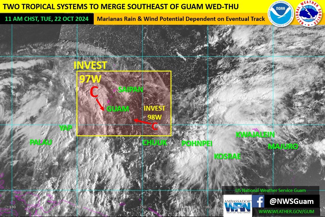
The National Weather Service’s weather chart yesterday tracking the movement of Invests 97W and 98W.


