Rain to persist this week; thunderstorms on Rota, Guam
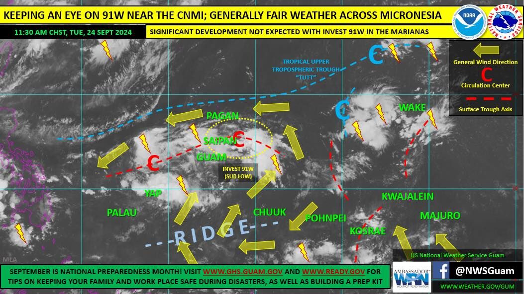
A classic wet season pattern will be in place across the CNMI and Guam this week while the trough and Invest 91W remains near, according to the National Weather Service in Tiyan, Guam.
NWS also said yesterday they are tracking a cluster of heavy thunderstorms in the coastal waters between Rota and Guam. Right now, NWS said they are producing frequent lightning, so residents are advised to avoid boating near these thunderstorms. If these thunderstorms develop or move over land, flooding may become a concern.
Despite its disorganized existence, NWS said 91W will be the focus for showers, thunderstorms, and locally heavy rainfall through the end of the week. Residents of the CNMI and Guam should expect a mix of sun, episodic showers (locally heavy at times), and variable winds—south to southwest, south of the trough axis; light and variable near the axis, and southeast to east, to the north.
A weak tropical disturbance, Invest 91W, sits just east of Saipan and is a poorly defined circulation within the trough axis extending east-west through the CNMI. Rated as “sub low” for development by the Joint Typhoon Warning Center, 91W is not expected to develop significantly days as it moves west. However, 91W will be the focus of showers, locally heavy rainfall, thunderstorms and stronger gusts. Regardless of its prognosis, NWS will keep a close watch on 91W while it remains in the region.
Elsewhere across the Guam Area of Responsibility, there are no suspect areas for significant development. Tropical cyclone development is not expected at least through the weekend.
Meanwhile, relatively fair weather prevailed across much of the NWS Guam Area of Responsibility last Tuesday, with the exception of the Marianas and Yap State. A surface trough and an embedded tropical disturbance, Invest 91W, will keep showers and thunderstorms nearby. Showers and thunderstorms are also across eastern Micronesia, associated with a couple surface troughs. A ridge of drier weather extends from Chuuk to south of Yap State and Palau.
For Yap State and Palau, NWS said fair weather wedges in from the southeast, with light winds in place at Palau and southwest winds at Yap. Expect showers and thunderstorms to linger near Yap through much of the week as winds converge toward the trough to the north. Drier weather will prevail across Palau into the weekend.
Meanwhile, NWS said gentle winds and pleasant weather persisted across much of Chuuk, Pohnpei, Kosrae and Majuro earlier this week. A surface trough near Kosrae will bring scattered showers to the state. Expect a benign weather pattern and light winds through the weekend across this region. Trades will increase early next week along with the likelihood for more showers.
For all the most up to date weather forecasts and information, please visit our web page at www.weather.gov/gum. (Saipan Tribune)
NWS


