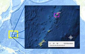
Saipan channel surveyed for US assets from WWII

|
Posted on Feb 28 2022

Tag:
,
Share

During the Deepwater Surveys of World War II U.S. Cultural Assets in the Saipan Channel expedition the team will conduct surveys using a REMUS 600 autonomous underwater vehicle, like the one shown here being deployed in 2021. The REMUS 600 can carry a suite of sensors, including sidescan sonar and a low-light camera system, and will reach depths as great as 600 meters (1,968 feet). (Image courtesy of Scripps Institution of Oceanography.)

From Feb. 24 to March 11, 2022, a team of researchers will explore the waters off Tinian and Saipan in the Northern Mariana Islands to locate and document U.S. warplanes lost during World War II.

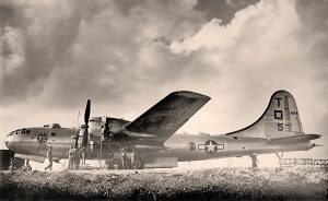
Tinian and Saipan served as major air bases during the final year of World War II, with B-29 bombers flying long-range missions to Japan. Many aircraft were lost on take off and landing. The lost aircraft have great significance to American history, yet the final resting places of these B-29s remain largely unknown.

Joltin’ Josie the Pacific Pioneer was the first B-29 bomber to enter the Pacific Theater of World War II. The aircraft was lost off Saipan on April 1, 1945. The team will search for the aircraft wreck site during the Deepwater Surveys of World War II U.S. Cultural Assets in the Saipan Channel expedition. Image courtesy of NOAA Ocean Exploration Deepwater Surveys of World War II U.S. Cultural Assets in the Saipan Channel.

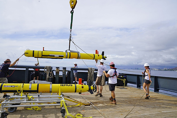
During this expedition, the team will conduct archeological surveys, map the seafloor in the region, and characterize the neighboring seabed habitat using state-of-the-art scientific methods and technologies, including shipboard systems, autonomous underwater vehicles, and a remotely operated vehicle, according to a release from NOAA Ocean Exploration

The proposed study region for the Deepwater Surveys of World War II U.S. Cultural Assets in the Saipan Channel expedition, in the waters of Tinian and Saipan in the Commonwealth of the Northern Mariana Islands, is inside the yellow rectangle. Inset: All survey data during the expedition will be collected inside the region of the pink rectangle in waters between 100 and 600 meters (328 – 1,968 feet) depth. Image courtesy of NOAA Ocean Exploration, Deepwater Surveys of World War II U.S. Cultural Assets in the Saipan Channel.

The expedition will result in an inventory of aircraft crash sites off Tinian and Saipan and data for site management and preservation; advance the efficiency, accuracy, and cost effectiveness of deepwater archaeology; and promote an increased awareness of maritime heritage through technologies that make underwater sites remotely accessible, such as 3-D models. Finally, the expedition team hopes to document and honor the final resting place of 76 U.S. service members who lost their lives in these waters. (PR)

Press Release
News under Press Release are official statements issued to Saipan Tribune giving information on a particular matter.

Related Posts

Disclaimer: Comments are moderated. They will not appear immediately or even on the same day. Comments should be related to the topic. Off-topic comments would be deleted. Profanities are not allowed. Comments that are potentially libelous, inflammatory, or slanderous would be deleted.